
On Friday and Saturday a harsh storm scrubbed the shoreline of southern Maine, revealing rarely seen glimpses of our history.
YORK, Maine — On Friday and Saturday a harsh storm scrubbed the shoreline of southern Maine, revealing rarely seen glimpses of our history.
Huge waves breached sea walls and then retreated, dragging a deep layer of sand off the beaches and temporarily transforming views at beaches in towns including York and Kennebunk.
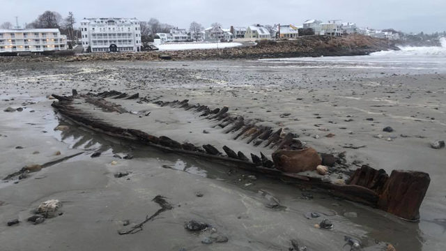
The remains of an old shipwreck resurfaced at Short Sands Beach in York, appearing for a second time since a storm dubbed “Nemo” struck in February.
Before that, the wreck had last been seen after the Patriots Day nor’easter in 2007. The old relic appears infrequently, adding to its mystique. Each time, roughly once every decade or two, new maritime history buffs are born.
When it was visible in 1958, locals speculated that it might be the remains of a “pink,” a term used to describe a small, square-rigged vessel with a flat bottom and a narrow stern.
But the wreck was again examined after a spring nor’easter uncovered it in 1980. Based on the type of construction, marine archaeologist Warren Riess hypothesized that the vessel is a sloop of about Revolutionary War age. The remains have been mapped and identified by the Maine Historic Preservation Commission as archaeological site ME 497-004.
In Kennebunk, the vague outline of another vessel was visible Sunday at the eastern end of Gooch’s Beach. Just a few ribs protruded from the sand in front of the bathhouses. Longtime residents said they remember the same wreck being briefly uncovered several times in the last 75 years. Its identity is uncertain, but two Kennebunk-built vessels are known to have been lost near the sandbar at the mouth of the Kennebunk River before the entrance was altered; one in 1818 and the other in 1820.
The 139-ton brig Merchant was built upriver by Kennebunk shipbuilder Nathaniel Gilpatrick and launched Oct. 13, 1804. After a West Indies trading career, she was cast away on the Kennebunk sandbar upon her return from Havana, Cuba, at the beginning of April 1820. All her cargo, sails and rigging were reportedly saved.
The 160-ton brig Columbia, launched upriver just a week after the Merchant, was owned by Richard Gilpatrick, Jeremiah Paul and Kennebunk Bank President Joseph Moody. Like the Merchant, she was engaged in West Indies trade with Cuba and Puerto Rico.
On Nov. 17, 1818, the Columbia returned to Kennebunk from Ponce, Puerto Rico, with a cargo of molasses, sugar, lignum vitae and hides. She also had a cache of specie aboard, likely in the form of gold and silver coins to enrich the coffers at Kennebunk Bank. The incident was reported in the Essex Register in 1818.
“In beating into port, to windward of the Fishing Rocks, the wind took her aback, and not having room to wear, she struck on one of the rocks, but immediately floated off — no danger was apprehended, but shortly after a Spanish passenger, who was confined to the cabin by sickness, came running on deck and informed that the vessel was half full of water — the people had just enough time to take to the boats losing all their clothes etc. before she sunk, leaving only the ends of her topgallant masts out of water.”
Capt. Lord managed to save one small bag of coins, but it was reported in contemporary newspapers that up to $1,000 in specie went down with the Columbia.
This past weekend’s storm also uncovered ancient tree stumps all over Gooch’s Beach. Similar roots and stumps hide under the sand at Wells Beach. Radiocarbon dating performed on those in 1959 by geologist Arthur M. Hussey indicates that about 3,000 years ago, the white pine trees were growing in a wooded upland. They were gradually drowned by the rising sea level.
During the Archaic period, Maine’s shoreline was much farther out to sea than it is today. From about 5,000 years ago to 3,600 years ago the rate of sea-level rise in this area was 5.5 inches per century. The rate of sea-level rise then slowed to 2 inches per century. The current rate of rise, as measured by the Portland tide gauge, is 7.5 inches per century — nearly four times faster than the rate over the last few thousand years.
Farther west at Kennebunk Beach, aka Mother’s Beach, another shipwreck rose from the sand over the weekend. This wreck was tentatively identified by historian and author Edward Rowe Snow after a March storm.
Bill Calder and Charles Robinson were the first to see crudely constructed ribs projecting 18 inches out of the sand on March 11, 1960. They called George Stevens, photographer for the Kennebunk Star. Some of the ribs were 2 feet wide and a foot thick, giving the wreck an ancient appearance. A 6-inch treenail (a wood fastening peg) removed from the planking had an unusual diamond-shaped wedge hammered into the end of it
The Industry was lost on her maiden voyage.
Soon the sand will reclaim these vestiges of the past and the usual views will be restored until the next perfect storm thrills onlookers with another peek.
